MATHEMATICS
Extended Learning Sequence
This extended learning sequence was taught as part of a university subject, Effective Teaching of Mathematics, Science and Technology. This subject required a series of lessons focused on an area of the Mathematics and Science curriculum to be taught to a small group of students in a Level 2 classroom at Noble Park Primary School (now merged with Springvale Primary School).
Working with another fellow university student we were given the freedom to devise, teach and assess a learning sequence, focused on any part of the mathematics curriculum.
Working with another fellow university student we were given the freedom to devise, teach and assess a learning sequence, focused on any part of the mathematics curriculum.
Planning

The topic of location and geometry was chosen as we felt it would link in well with the school's term topic of transport. We thought that this would be a good topic for this level since they are developing clearer ideas of self and what their place is in the world. We also thought that, given only limited lesson slots, we would be able to achieve simple but effective outcomes in this learning area.
We believed that the activities in this topic would link well with the children's developing spatial awareness as they learn to make keen observations and record their observations in appropriate formats. We could also see potential for cross curricula links with the Domains of communication, as they have opportunities to interpret and explain maps and diagrams, and thinking processes as they explore the environment around them, making accurate observations.
VELS
The standards covered in this extended learning sequence are as follows:
Space
Resources
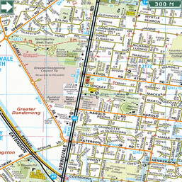
Throughout our lesson planning we attempted to make our tasks and activities both stimulating and challenging for our students. Our lessons included a variety of maps, including an atlas, melway map and a school map. These maps depicted locations at a school, local and national level. Our activities also included a number of opportunities for students to be creative in demonstrating their mathematical understandings and knowledge.
We believed that the activities in this topic would link well with the children's developing spatial awareness as they learn to make keen observations and record their observations in appropriate formats. We could also see potential for cross curricula links with the Domains of communication, as they have opportunities to interpret and explain maps and diagrams, and thinking processes as they explore the environment around them, making accurate observations.
VELS
The standards covered in this extended learning sequence are as follows:
Space
- Students specify location as a relative position, including left and right, and interpret simple networks, diagrams and maps involving a small number of points, objects or locations.
- Students learn to construct and follow directions, informal maps, diagrams and routes to locations in the local environment.
Resources
Throughout our lesson planning we attempted to make our tasks and activities both stimulating and challenging for our students. Our lessons included a variety of maps, including an atlas, melway map and a school map. These maps depicted locations at a school, local and national level. Our activities also included a number of opportunities for students to be creative in demonstrating their mathematical understandings and knowledge.
Sequence of Activities
Engage & Explore
Learning Objectives: Introduction to the topic of location and maps and the concept of bird's eye view.
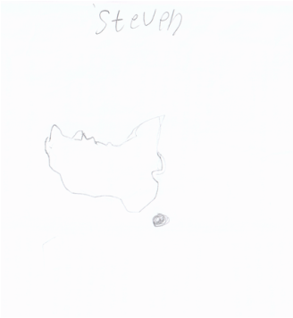
- We begun our lesson sequence with a simple assessment task incorporating geometry, space and the drawing of maps and diagrams. Students drew their own interpretations of what shape they believed Australia to be to ascertain what they know about the country they live in. This was followed by a group discussion of all the students diagrams of Australia.
- As a group, we open an atlas and look at the map of Australia, probing for understanding of the shape, location, distance, size and the concept of maps. We introduced the concept of bird's eye view, with the map of Australia on the floor and us looking down on it.
- We then opened a street dictionary and found the school. We asked if any students knew their address. No students were able to give us enough detail to use the street directory, but students were keen to look at the map, and some recognised features such as main roads or parks that they knew.
Explain & Elaborate
Learning Objectives: Focus on the concept of a bird's eye view in terms of drawing and understanding maps and diagrams relating to understanding of location, position, distance and direction.
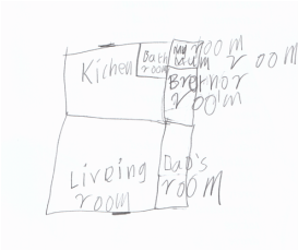
- After these experiences of maps, diagrams and the concept of a bird's eye view, we asked the children to draw a map/diagram of their house, to show us details such as the location of different rooms. We though this task would not only give us an indication of their understanding of bird's eye view, but it is also a meaningful activity for them.
- We found straight away that the children had not fully understood the use of bird's eye view. Therefore in our group discussion, we referred to the map of the school (used for emergency evacuations) and asked them to locate the classroom, then the toilets. We asked hem to describe using the map; how to get from the classroom to the toilets. We again talked about the concept of a bird's eye view, and how the map is drawn from that perspective, to help the children develop further understandings of the concept.
- From what we understood about the students knowledge from the previous lesson, we recapped and reminded the students of what a bird's eye view is, and how we draw and look at maps from that perspective.
- As a group, we created a diagram of the classroom on a large sheet of paper, asking questions such as "how can we draw the classroom on paper?" With some guidance, students were able to point out key features of the classroom, and indicate where they should go on the diagram. The students were using their observation skills and spatial awareness skills to understand what to put in the diagram, and where, and how large in comparison with other things.
Evaluate
Learning Objectives: Students demonstrate their understanding of the concept of a bird's eye view and discuss the purpose of such diagrams, in a creative and meaningful task.
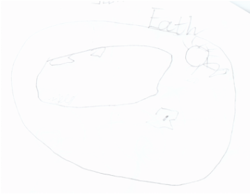
- Students were given the opportunity to create their own maps or diagrams, from the perspective of a bird's eye view. We made suggestions such as, draw a diagram of your bedroom at home, make a treasure map, draw a map of your favourite park etc.
- We roamed around the students as they worked, asking questions relating to location, position, distance and direction that were involved in their diagrams.
- Group presentation, where each child could share their work with others, adding to further understanding of maps and diagrams. During the presentations we looked for how the children were describing things like location, direction and distance.
Assessment
Diagnostic
- Students map of Australia
- Group discussion of of the diagrams of Australia.
These assessment activities allowed us to probe the students prior knowledge, but also served as an introduction to the topic of location and maps. The students participation in these activities allowed us to determine the learning needs of the students and helped us to understand and determine how best to teach them.
Formative
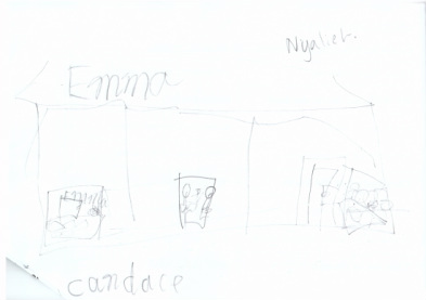
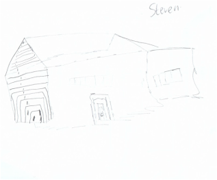
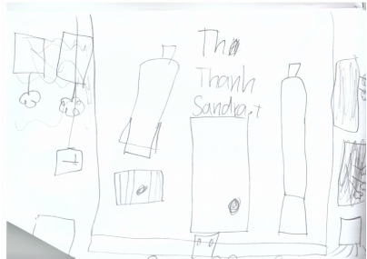
- Students' maps of their houses.
- Group discussions on location, directions and bird's eye perspective.
- Teacher observations of student learning.
Throughout this sequence of lessons, these formative assessment methods not only enabled us to determine the depth and degree of student understanding but also informed future teaching and learning activities. This was clear in the students' maps of their houses where they showed that they had not fully understood the use of a bird's eye view. Students drew pictures of the front view of their house while others showed some bird's eye view perspective, but not fully, using arrows as part of their diagram to show location and movement through the house. This informed instructional planning which provided further learning opportunities for students to understand this concept more fully.
Click on an image to view a larger version
Summative
With these informal maps, the students' knowledge and understandings were recorded and compared with previous observational records of students' understandings, knowledge and abilities. These were then complied into a rubric from which we were able to compare with the students pre-instructional understandings and determine the extent and developments of the students learning regarding the topic.
(Please click on the navigation arrows in the upper right hand corner to view this slideshow)
- Students maps drawn from the perspective of a bird's eye point of view
With these informal maps, the students' knowledge and understandings were recorded and compared with previous observational records of students' understandings, knowledge and abilities. These were then complied into a rubric from which we were able to compare with the students pre-instructional understandings and determine the extent and developments of the students learning regarding the topic.
(Please click on the navigation arrows in the upper right hand corner to view this slideshow)
Evaluation & Reflection
Overall we felt that the sequence of teaching strategies and learning activities employed were fairly successful in developing the students learning and knowledge regarding the concept of a bird's eye view. We believe we structured our lessons with activities that were both stimulating and challenging for our students given the limited time and resources available.
Feedback
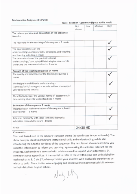
To the right is the assessment rubric and feedback from the unit supervisor for this school-based university subject.
